My name is Thomas Cortez and currently I am pursuing my Masters of Science in Aeronautics from Embry-Riddle Aeronautical University. I am a graduate of ERAU-Daytona Beach in 2012 and very proud to be back! This blog is meant to track my academic progress, experiences within the field of unmanned systems, and professional research.
Unmanned Systems Defined
Typical definitions of unmanned systems tend to indicate a mindless, emotionless conglomerate of wires, sensors, and software meant to accomplish a task assigned by a human counterpart. However, I feel unmanned systems are more than a helping hand, so to speak. To me, they are combat multipliers, our watchful eye in the sky; a medical transport, delivery service, or weekend hobbies. Though many aerial, ground, space or sea-based unmanned platforms may be fully controlled by humans, autonomous systems also provide tremendous assistance in simple or complex tasks; making aspects of our professions just a little easier..
Unmanned Aerial Systems Uses and Potential Conflicts
For this week’s blog post, the use of unmanned systems in any capacity with regards to ethics, safety, privacy, and loss of link will be discussed. For my example, I will use the example of Williamson County and Austin Police departments deploying an unmanned aerial asset for real-world operations; specifically to help map flood zones after heavy rains and to provide intelligence, surveillance, and reconnaissance data on a suspected domestic terrorist who utilized explosives to kill civilians in Austin, Texas. Additionally, arguments and research from peer-reviewed sources will highlight the ethical, safety, and privacy concerns (in regard to federal regulations) of deploying such assets in real-world events.
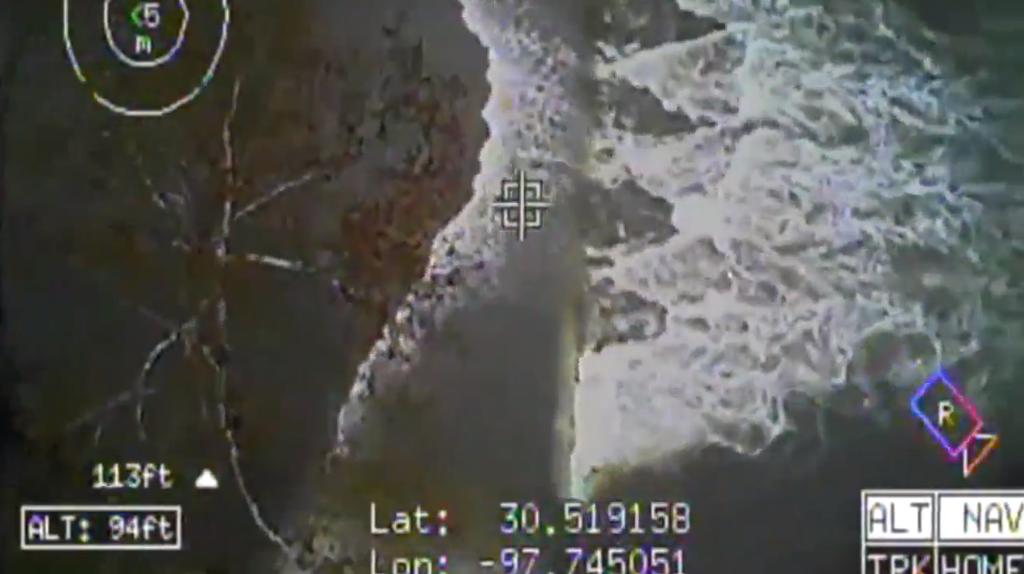
The deployment of UAS’s for dangerous situations and ISR purposes have proven fruitful. In early January 2019, massive flooding occurred around the Austin metropolitan area due to continuous rain. Rather than sending police officers to investigate low-water crossings, Williamson County Sheriff’s Department (WCSD) deployed their UAS to investigate the area. As Figure 1 depicts, the information gathered from the aerial photography and video from the UAS allowed the department to issue warnings to local residents; preventing further accidents or deaths via rapid dissemination of information.
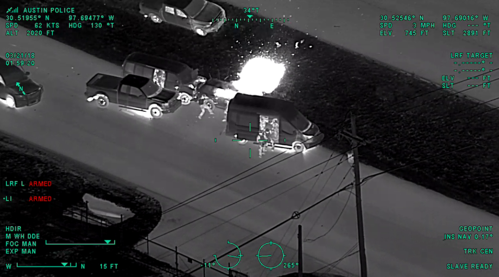
The use of this exact same UAS assisted police officers in the capture of a suspect who evaded police and fired upon law enforcement officials (Cantu, 2019). To do this, Forward-Looking Infrared (FLIR) enabled components were fitted to the UAS and upon deployment, police officers were able to locate the suspect in less than ten-minutes without incident. FLIR systems were also used in the attempted capture of Mark Anthony Conditt (Figure 2), the Austin-bomber suspected of creating 7 homemade bombs which resulted in the deaths of 3 people, including himself (CBS Austin, 2018). In each of these examples, in the event that the UAS lost linkage or control with the operator, a pre-programmed contingency option directed the platform to return to the point of origin. The rapid deployment of such systems with the capability to view in austere conditions further highlights the benefits of UAS’s used by law enforcement.
However, the integration of UAS’s within law enforcement agencies would have to overcome current FAA regulations as well as adhering to privacy concerns the public and some within state legislatures have voiced. Argued by Dow Chemical Co. v. United States, 476 U.S. 227 (Burger & Supreme Court of the United States, 1986; Bier & Feeney, 2018) aerial photography of a business without proper consent is considered invasion of privacy. Though the court of appeals reversed the decision in favor of Dow Chemicals, this is but one example of what may arise of law enforcement UAS’s conducted missions outside their scope of work.
In correlation to privacy concerns, some of the American public may view the use law enforcement UAS’s as an abuse of power. Discriminatory targeting, automated enforcement, and voyeurism have been logical arguments made victims of such issues. The latter occurred when a New York Police Department helicopter filmed a couple engaging in sexual acts and continued to record for over four minutes (Stanley & Crump, 2011). When asked, NYPD denied this filming was an infringement on people’s privacy and they were making sure nothing illegal was occurring (Dwyer, 2005; as cited in Stanley & Crump, 2011).
Within Stanley and Crump’s (2011) publication of recommendations on how to utilize unmanned aircraft for law enforcement purposes, two cases (in conjunction with Dow Chemical Co. vs. United States) ultimately brought before the United States Supreme Court acted as a catalyst that would inevitably associate themselves to future UAS uses. In the State of California vs. Ciraolo, police had received an anonymous tip that a local resident was growing marijuana in his backyard and selling it. Acting on this tip, police investigated the issue but were unable to clearly view the backyard due to high fences and brush blocking the view. As an alternative, police decided to borrow an aircraft from a local airport and use it to view the contents of the backyard to which they discovered a large amount of marijuana being grown. Ciraolo was subsequently arrested yet argued in state and federal courts “that his Fourth amendment rights were violated because the government did not get a warrant” (Stanley and Crump, p. 13). The Supreme Court ruled in favor of the State of California because “[a]ny member of the public flying in this airspace who glanced down could have seen everything that these officers observed” (Burger & Supreme Court of the United States, 1986; as cited in Stanley and Crump, 2011, p.13).
Similar in judgement, in the State of Florida vs. Riley, another tip led to the arrest of Michael Riley for the cultivation and distribution of marijuana. Riley had been growing marijuana in his greenhouse, but law enforcement was unable to view the suspected crops because of a lack of visibility. Using an aircraft, police were able to verify the presence of marijuana by looking into the greenhouse via two missing ceiling panels on the roof. Just as Ciraolo experienced, the Supreme Court ruled this was not a violation of his Fourth Amendment rights due to anyone who could have flown the same route would have seen the same thing and it was open to public view (Dwyer-Moss, 2018).
References
Bier, D. & Feeney, M. (2018). Drones on the Border: Efficacy and Privacy Implications. CATO Institute. Retrieved from https://www.cato.org/publications/immigration-research-policy-brief/drones-border-efficacy-privacy-implications
Burger, W. E. & Supreme Court of The United States. (1986). U.S. Reports: Dow Chemical Co. v. United States, 476 U.S. 227. [Periodical] Retrieved from the Library of Congress, https://www.loc.gov/item/usrep476227/.
Cantú, F. (2019). Thermal Imaging from WilCo Drone Helped Arrest Police Shooting Suspect. CBS Austin. Retrieved from https://cbsaustin.com/news/local/thermal-imaging-from-wilco-drone-helped-arrest-police-shooting-suspect
CBS Austin. (2018). APD Releases Helicopter Video of Bomber Mark Conditt’s Last Moments. CBS. Retrieved from https://cbsaustin.com/news/local/apd-releases-helicopter-video-of-bomber-mark-conditts-last-moments
Dwyer, J. (2005). Police Video Caught a Couple’s Intimate Moment on a Manhattan Rooftop. New York Times.
Dwyer-Moss,
J. (2018). The Sky Police and the Fourth Amendment. Albany Law Review. 81(3). 1047-1070. Retrieved from
http://bi.galegroup.com.ezproxy.libproxy.db.erau.edu
/essentials/article/GALE%7CA547694408?u=embry&sid=summon
Stanley, J., & Crump, C. (2011). Protecting Privacy from Aerial Surveillance: Recommendations for Government Use of Drone Aircraft. American Civil Liberties Union. 6(6). 1-22. Retrieved from https://www.aclu.org/report/protecting-privacy-aerial-surveillance-recommendations-government-use-drone-aircraft
Benefits of Using Firefighting UGV’s.
Though firefighters are an integral part of everyday society—providing emergency medical care and extraction of personnel from structure fires—every life that can be saved to ensure the continuation of this profession is a factor worth discussion. The development of firefighting robots that assist in equipment transport, victim transport, fire extinguishing, and critical environment data have greatly enhanced the capabilities of first-responders. Additionally, these platforms act as force multipliers; enabling the operators on the ground greater situational awareness of their environment to conduct search and rescue operations while decreasing the loss of unit or victim’s lives.
Schneider and Wildermuth (2017) highlighted the possible applications of robotics in firefighting operations with potential technologies to assist in extinguishing, pathfinding, and detecting of dangerous conditions. With a multitude of sensors available for unmanned systems, these firefighting robots also act as a chemical, biological, radiological, nuclear and explosive (CBRNE) asset for first responders to utilize. In recent news, oil refineries or chemical plants were subject to destruction; whether accidental or intentional. The use of such a platform as this assist’s first responders in analyzing dangerous levels of toxins while keeping its human counterparts at a safe distance until conditions are optimal. Additionally, tasks given to the robot could assist in transporting survivors and heavy equipment in/out of the structure. Having an operator of the firefighting robot may be more sensible than having a fully autonomous robot for several reasons: 1.) the operator can utilize judgement and other human emotions to make critical decisions in a timely manner and 2.) the reaction time to a developing dangerous situation may provide “intuition” that is not experienced by machines. Mission analysis, course of action development and analysis, course of action comparison, and course of action approval are somewhat natural processes we as humans think when an immediate choice is warranted. In austere environments, such as those experienced by firefighters, gathering real-time critical information of their operational area could greatly assist the success of their prescribed mission; whether it be reconnaissance or rescue operations.
Within these environments, low-visibility and unknown layouts are some of the most important factors when conducting rescue operations. Before entry into a structure, firefighting robots assist the ground personnel by mapping current conditions within each room, provide temperature readings, and provide material support via transportation of heavy equipment. For less intense fires, these platforms could also detect and extinguish fires before becoming too great and surpassing the capabilities of the deployed asset. The use of such systems greatly reduces the number of first-responder deaths experienced on average every year. Fahy, LeBlanc, and Molis (2017) of the National Fire Protection Association (NFPA) detail in their annual report that 69 firefighters died in the line of duty in 2016. Of the 69 deaths, 15 were caused by structure fires while conduction assessment/search and rescue operations; accounting for approximately 22 percent of all deaths (p. 3). Overall, the use of unmanned firefighting robots has proven fruitful when reducing the lives lost in the line of duty. Hopefully, more widespread use of these systems would not replace the human firefighter, but rather augment their capabilities in completing their tasks in a timely and efficient manner.
References
Fahy, R., LeBlanc, P., & Molis, J. (2017). NFPA: Firefighter Fatalities in the United States – 2016. Retrieved from http://www.nfpa.org/News-and-Research/Fire-statistics-and-reports/Fire-statistics/The-fire-service/Fatalities-and-injuries/Firefighter-fatalities-in-the-United-States
Schneider, F. & Wildermuth, D. (2017). Using Robots for Firefighters and First Responders: Scenario Specification and Exemplary System Description. 18th International Carpathian Control Conference (ICCC). (216-221). Retrieved from http://ieeexplore.ieee.org.ezproxy.libproxy.db.erau.edu
/document/7970400/
Unmanned Maritime Systems
The development and deployment of autonomous or semi-autonomous unmanned platforms into combat/defense operations provided greater situational awareness and intelligence capability to ground commanders in recent conflicts throughout the world. Now that operations (United States and its allies or near-peer) have digressed slightly, the integration of autonomous surface vehicles for maritime intelligence, surveillance, and reconnaissance operations seems to be the “next big thing”; each providing data and defense capabilities for those who deploy them.
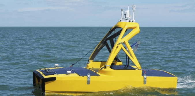
Centered around a specific event, three articles detailing the C-Enduro Autonomous Surface Vehicle by L3 (formerly ASV Global) and its integration into the Royal Navy (UK) provide insight into the constant development of autonomous maritime platforms; as well as their associated sensor packages and collection capabilities.
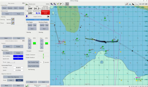
In February of this year, L3 ASVGlobal delivered the C-Enduro autonomous surface vehicle to the United Kingdom’s Royal Navy for operational use regarding data collection supporting the mine countermeasures and hydrographic capability (MHC) program (Scott, 2019; ASVGlobal, 2019; AUVSI, 2019). The C-Enduro is a 4.8 meter, fully autonomous above surface platform designed to operate in an array of maritime conditions with the sole mission of collecting and disseminating data. Powered by 10 high-efficiency solar panels capable of an electrical output of 1100 watts, wind turbines (electrical output of 500 watts) and/or a diesel powerplant, the C-Enduro can operate in a designated area for over 30+ days (ASVGlobal, 2019). Additionally, sensors can be mounted on either the bottom of the platform or above; each powered by the solar and/or wind generators. Sensors that can be attached to this autonomous surface vehicle include (but limited to) L3 ASVGlobal’s 360 VIR camera, meteorological sensor packages, side-scan sonar, and electronic-warfare platforms. Communication with the C-Enduro is possible via over-the-horizon broadband satellite linkage using ASView and the associated ASView-Bridge Operator Interface (ASVGlobal, 2019). As seen in the image below, the interface allows the observer to control the surface vehicle, provide alternate navigation, integration of multiple autonomous surface platforms, and control the on-board sensors, if applicable.
Though autonomous surface vehicles have been thought of more as a scientific-based platform for research and observation, the integration of such technology into defense applications is not surprising. Most unmanned systems—whether aerial, maritime, space or ground-focused—either started as a military-funded program or quickly became such a mission-focused asset. Personally, the deployment of autonomous surface vehicles into various theaters of operation creates a larger operating picture for all branches of any military. For example, the use of surface vehicles in the Pacific (likely within near-peer territories such as North Korea, China, or Russia) provides critical intelligence of underwater or above water activities each respective threat may be conducting.
In short, the integration of autonomous surface vehicles for maritime defense operations seems to be on the rise. Either for data collection or near-peer potential threats, sightings of such autonomous platforms will become more commonplace in the very near future.
References
Association for Unmanned Vehicle Systems International (AUVSI). (2019). L3 Delivers Long-Endurance Autonomous Vessel to Royal Navy. Retrieved from https://www.auvsi.org/industry-news/l3-asv-delivers-long-endurance-autonomous-vessel-royal-navy
ASVGlobal. (2019). C-Enduro Product Information. Retrieved
from https://www.asvglobal.com/product
/c-enduro/
ASVGlobal. (2019). C-Enduro Long Endurance ASV. Retrieved from https://www.asvglobal.com/wp-content/uploads/2018/09/C-Enduro_Datasheet_2018-update.pdf
ASVGlobal. (2019). L3 ASV Delivers Data Gathering Autonomous Vessel to the Royal Navy. Retrieved from https://www.asvglobal.com/l3-asv-delivers-data-gathering-autonomous-vessel-to-the-royal-navy/
ASVGlobal. (2019). ASView Technology. Retrieved from https://www.asvglobal.com/asview-technology/
Scott, R. (2019). Sea Platforms: C-Enduro USV Delivered for
Military Data Gathering. Jane’s International
Defence Review. Retrieved from https://janes-ihs-com.ezproxy.libproxy.db.erau.edu
/InternationalDefenceReview/DisplayFile/fg_1644070?edition=2019
 Development & Application of Unmanned Systems